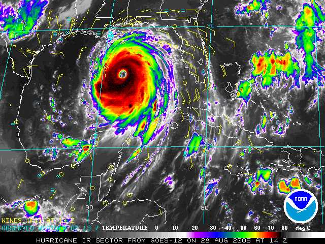
Hurricane Katrina is an extremely dangerous Category 5 storm on the Saffir-Simpson scale. Maximum sustained winds are at 175 mph. Katrina continues not only grow stronger, but it continues to grow larger. Hurricane-force winds extend 90 miles from the center on the eastern side of Katrina, 75 miles to the northwest and 50 miles to the southwest. Sustained tropical storm force winds are not far from the Gulf Coast and should move in later this afternoon. Katrina has turned and is moving northwest at 13 mph with a turn to the north expected tonight.
Everyone along the northern Gulf of Mexico should be completing preparations for a major hurricane and take heed of evacutation orders. Hurricane warnings are up from Morgan City, La., to the Florida-Alabama border. This includes the city of New Orleans and Lake Pontchartrain. A tropical storm warning and a hurricane watch have been issued from the Alabama-Florida border eastward to Destin, Florida and from west of Morgan City to Intracoastal City, Louisiana.
A storm surge of 20 to 25 feet or more is possible along and to the east of Katrina's landfall point Monday. On top of the water rise, pounding waves of 20 to 40 feet will produce catastrophic damage at coastal locations.
Effects from Katrina will not be confined to coastal areas. Once Hurricane Katrina makes landfall, it will progress inland Monday into Tuesday with a trail of flooding rains and damaging winds across Mississippi and Alabama and then into Tennessee. Torrential, flooding rainfall is possible with the remnants of Katrina well inland, possibly into the Ohio Valley, Great Lakes and the Northeast later this week.
This would be a good time to pray.
Katrina has already claimed seven lives in Florida.
My prayers go out to the families of those lost in the storm, as well as to all those impacted by Hurricane Katrina.
Pray that Katrina weakens and pray for the safety of those in her path.
Sunday, August 28, 2005
Hurricane Katrina
![]()
![]()
Subscribe to:
Post Comments (Atom)


No comments:
Post a Comment